About
About
History
In 1972 when the Nebraska Legislature passed LB 1357, which consolidated 154 special interest districts into 24 multi-purpose natural resources districts (later reduced to 23 due to a merger), not everyone was in favor of the change. In fact much of the most boisterous opposition originated in Richardson County from those who expressed concern about losing what they perceived to be their local control. Ironically today Nebraska’s Natural Resources District system is envied by others across the country for exactly the opposite – NRDs possess unusual local control while maintaining a large enough tax base to accomplish major projects.
The Natural Resources Districts were given statutory responsibility outlined in Sections 2-3229, R.R.S. 1943. This section states “The purposes of the Natural Resources Districts shall be to develop and execute, through the exercise of powers and authorities contained in this act, plans, facilities, works and programs relating to:
- Erosion prevention and control,
- Prevention of damages from flood water and sediment,
- Flood prevention and control,
- Soil conservation,
- Water supply for any beneficial uses,
- Development, management, utilization, and conservation of groundwater and surface water,
- Pollution control,
- Solid waste disposal and sanitary drainage,
- Drainage improvement and channel rectification,
- Development and management of fish and wildlife habitat,
- Development and management of recreational and park facilities, and
- Forestry and range management.”
A History of Nebraska's Natural Resources Districts PDF
Who We Are
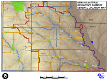
The Nemaha Natural Resources District is a political subdivision of the State of Nebraska situated in the southeastern most counties of Nebraska. Boundaries for the eight-county District are based on the hydrologic boundaries of the Nemaha River basin. A 21-member publicly elected board of directors governs the District with help from a staff of about 18 full-time employees. State statute dictates 12 areas of responsibilities for NRDs, but each put differing emphasis on those areas. In the Nemaha NRD, flood and erosion control, soil conservation, water quality and quantity, and outdoor recreation are some of the key concerns.
Budget
NRDs operate on an annual budget with revenues generated principally from local property taxes. A limit of 4.5 cents per $100 of property valuation may be levied. In addition tax funds are often used to leverage other state and federal grants and funds.
The Fiscal Year 2025 (July 1, 2024 through June 30, 2025) approved levy is 0.29999%. The following is a breakdown of the FY25 budget.
| FY25 Budget Expense Category | Budgeted Amount | % of Budget |
|---|---|---|
| Watershed & Flood Control Projects |
$889,000 |
20% |
| Recreation | $262,730 | 6% |
| Personnel & Director Expense | $1,603,277 | 36% |
| General Operation & Maintenance | $384,287 | 9% |
| Conservation Assistance | $233,600 | 5% |
| Water Quality/Quantity | $143,250 | 3% |
| Capital Expenditures | $110,500 | 3% |
| Cash Reserve, Sinking Funds, & Misc. | $760,954 | 18% |
| Information & Education | $17,095 | <1% |
| Total FY 25 Budget | $4,404,693 |
Annual Dues & Memberships FY25
Association of State Floodplain Managers - $180
Nebraska Floodplain & Stormwater Managers Association - $35
Groundwater Management Districts Association - $500
National Watershed Coalition - $75
Southeast Weed Management Association - $500
Testing Ag Performance Solutions - $290
Nebraska Water Resources Association - $1,950
American Water Resources Association - $180
Nebraska Association of Resources Districts - $33,228
National Association of Conservation Districts - $775
Facts
| Location: | All of Johnson, Nemaha, Richardson Counties Most of Otoe, Pawnee Counties Parts of Cass, Gage, Lancaster Counties |
| Population: | 44,560 (2010 Census) |
| Size: | 2,402 square miles/1.5 million acres within the Big & Little Nemaha River Basins |
| Funding: | Up to 4.5 cents per $100 valuation (local property taxes) State and Federal grants & funds Sales of goods and services |


